Drifting buoys are an important marine innovation that has changed the way we monitor and understand ocean dynamics. They serve not only as data collectors, but also as a window into the ocean’s hidden secrets. With its ability to float and move with the current, the drifting buoy automatically adapts its movements to the highly variable environmental conditions. This enables direct and continuous data collection from areas of open water that are often difficult to reach by research vessels or shore stations.
Advances in sensor technology and satellite communication systems have taken drifting buoys to another level. Equipped with various sensors to measure sea surface temperature, air pressure, wind speed, and water chemistry parameters, drifting buoys can provide a comprehensive picture of the physical and chemical conditions of the waters. The resulting data is then transmitted in real-time to research centres on land, where scientists and meteorologists can immediately analyse it to predict extreme weather phenomena, climate change and current movements that could affect marine ecosystems.
In the context of global climate change, the role of drifting buoys is becoming increasingly important. Sea surface temperatures measured by buoys can be early indicators for phenomena such as El Niño or La Niña, which affect global weather patterns and ecosystem balance. In addition, data collected by drifting buoys support the development of more precise weather prediction models, assisting communities and governments in taking mitigation and adaptation measures against natural disasters such as tropical storms and floods.

The advantage of drifting buoys lies in their flexible ability to operate in extreme environments. In often challenging ocean conditions-such as high waves, storms and sudden changes in currents-drifting buoys can still function well. This concept has been applied in various global monitoring networks, such as the Global Drifter Programme (GDP), which uses hundreds to thousands of buoys to provide valuable data to scientific communities around the world. Through these international collaborations, data from drifting buoys not only improves understanding of ocean dynamics, but also contributes to climate change mitigation efforts and more sustainable management of marine resources.
With its various advantages and functions, the drifting buoy is not just a tool for collecting data, but also a symbol of technological advancement in ocean monitoring that enables a closer relationship between humans and nature. This technology opens up opportunities for more in-depth research on the interactions between the ocean and the atmosphere, and provides a scientific basis for more efficient natural resource management policies. With technological advances and increased international cooperation, drifting buoys are expected to continue to play an important role in maintaining the balance of marine ecosystems and supporting global environmental sustainability.
Drifting Buoy Design and Structure
- Shape and Material
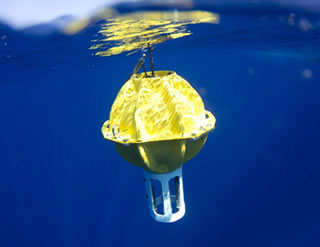
- Physical Shape: Drifting buoys usually have a spherical, cylindrical, or elliptical shape, with a customised size for stable floating. This design helps reduce the possibility of the buoy capsizing or being disturbed by large waves.
- Material: The materials used are generally fibreglass, durable plastic, or other composite materials that are resistant to corrosion, UV exposure, and extreme conditions in the ocean. These materials ensure that the buoy remains functional over a long period of time, even in harsh environments.
- Main Components
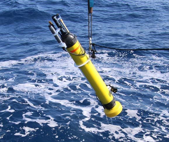
- Sensor Unit: Drifting buoys are equipped with various sensors to measure environmental parameters. These sensors include:
- Sea Surface Temperature (SST): Thermistor or infrared sensor to accurately measure water temperature.
- Air Pressure: A barometer used to measure pressure fluctuations at sea level, which is closely related to weather conditions.
- Wind Speed and Direction Sensor: Some models are equipped with an anemometer to measure wind speed and direction.
- Additional Sensors: Some drifting buoys are equipped with sensors to measure salinity, pH, dissolved oxygen concentration, and even chemical sensors to detect pollutants.
- Positioning and Navigation System: Equipped with GPS modules or other satellite-based tracking technologies that allow real-time monitoring of the buoy’s position. This location data is crucial for mapping sea surface currents and water mass movements.
- Antenna and Communication System: These components ensure the data collected can be transmitted to ground stations via satellite networks such as Argos, Iridium, or Inmarsat. Satellite communication allows operations in very remote areas, without the need for adequate ground infrastructure.
- Drogue or Sea Anchor (Optional): Some drifting buoys are equipped with a drogue, which is a kind of underwater anchor that helps the buoy follow the current more accurately. The drogue serves to reduce the direct wind influence on the buoy, making the surface current movement data more representative.
- Sensor Unit: Drifting buoys are equipped with various sensors to measure environmental parameters. These sensors include:
Drifting Buoys Work
- Surface Float and Sensor
- Function: This section contains sensors to measure important parameters such as sea surface temperature, air pressure, wind speed, and sometimes salinity.
- How it works: These sensors collect data periodically and transmit it via satellite communication systems, providing real-time information on ocean conditions.
- Drogue (Sea Anchor)
- Function: A drogue is an underwater ‘anchor’ usually placed about 15 metres below the surface.
- How it works: With a drogue, the buoy tends to follow the water currents rather than being directly affected by the wind. This ensures that the movement of the buoy better reflects the motion of the water mass within the layer being measured.
- Navigation and Data Transmission System
- Function: Uses GPS technology or other satellite tracking systems to periodically determine the position of the buoy.
- How it works: Position data is combined with environmental measurements, and the information is transmitted to a data centre via a satellite network. This process allows researchers to monitor the movement of currents as well as integrate the data with numerical models for weather forecasting and oceanographic studies.
- Power and Automation Systems
- Function: Usually powered by batteries (often with solar panels) to ensure long-term operation.
- How it Works : Once deployed at sea, the drifting buoy automatically activates sensors and transmission modules without the need for human intervention, so that data is transmitted continuously according to pre-set intervals.
Drifting Buoys strengths and weaknesses
Strengths:
- Broad and Real-Time Monitoring Capabilities: Because drifting buoys move with ocean currents naturally, they can collect data from a very wide area, including water areas that are difficult to reach by ships or shore stations. With satellite communication systems, the buoys can transmit data in real time, so information on ocean conditions such as surface temperature, air pressure, and wind speed can be used immediately for weather forecasting and climate analysis.
- Efficient Operating Costs : Compared to research vessels or fixed stations, drifting buoys are cheaper to manufacture, launch and maintain, enabling the installation of larger observation networks globally. Buoys can be released from various platforms such as research vessels, commercial ships, or even aircraft, allowing for great operational flexibility.
- Measurement Flexibility: Drifting buoys can be equipped with a variety of sensors (e.g. temperature, pressure, salinity, and anemometer sensors) that enable the measurement of various oceanographic and meteorological parameters according to research needs. As part of international programmes such as the Global Drifter Programme, these buoys are integrated with each other to produce a comprehensive and consistent global dataset.
- Minimal Interference from Land-based Infrastructure: Because they do not rely on land infrastructure, drifting buoys can operate in remote areas and under extreme conditions, providing data from locations rarely or unreachable by other instruments.
Weaknesses
- Limitations in Control and Stability: Without an active propulsion system, the buoy simply follows the current and wind forces. If the drogue (sea anchor) is detached, the buoy becomes more affected by the wind, so the resulting data can become less representative of the movement of the water mass. Sudden changes in sea conditions (e.g. large waves or storms) can cause fluctuations in the buoy trajectory, which in turn affects the consistency and accuracy of the data.
- Measurement Limitations: Drifting buoys generally only measure parameters in the surface layer of the ocean, so information about conditions at deeper depths cannot be obtained directly. Data quality is highly dependent on the condition and calibration of the sensors. Damage or errors in the sensors can lead to measurement errors that impact the overall data analysis.
- Operational Life and Energy Limitations: While many buoys are equipped with batteries designed to last a long time (often with the addition of solar panels), operational life is limited. When the power runs out, the buoy can no longer transmit data in real-time. Buoys that suffer damage or loss of drogue require replacement or repair, which entails additional costs and logistics.
- Environmental Influences and Physical Risks: Drifting buoys must endure highly variable conditions in the ocean, including storms, high waves, and extreme temperatures. This increases the risk of damage to its structure and electronic components. It is possible for buoys to become trapped, struck by vessels, or lost due to human activity, which can lead to inconsistent data or loss of equipment.